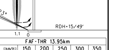
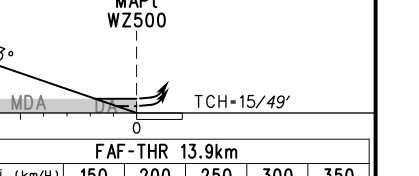
在翻阅温州的国内航图时,我发现03号ILS的图上写的是RDH,但是03号RNAV(GNSS)的图上写的是TCH。 

相同的数值却用不同的名字表示,这是为什么呢?
我先去找了AIP的简字简语,发现只有“RDH”的定义:“Reference datum height (for ILS)仪表着陆系统基准数据点高”
ICAO对于两者的定义为:
RDH = Reference datum height (RDH). The height of the extended glide path or a nominal vertical path at the runway threshold.
TCH = Threshold crossing height
在微博上问了一些人,CAVOK_祎告诉了我一个非官方的答案:
“TCH and RDH are one in the same, but in the real world the radiated signal is influenced by the surrounding environment resulting in the TCH and RDH not necessarily being equal.”
我在FAA上又找到了个文件:“ASSESSMENT OF THE EFFECTIVENESS OF THE RDH/ARDH EVALUATION METHODOLOGY FOR THE ILS GLIDE SLOPE”
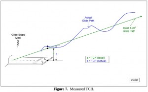
我只是粗略地看了一些图片,大概明白是什么道理了。在以前,当一个下滑道建立好之后,可以用它的安装角和设备离跑道入口的距离来换算出下滑道信号在跑道入口上方的高,称之为TCH,计算方法见下图:
后来,因为受环境的影响,实际的下滑道信号和理想的下滑道信号之间有区别,所以计算的TCH和实际的TCH之间也有差别:
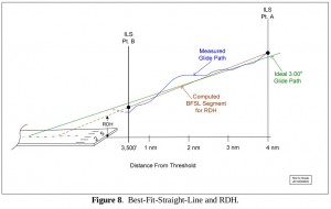
再后来,干脆用飞机去飞一遍,测量实际的下滑道路径,并在路径上选择两个点,画一条直线,直线的延长线在跑道入口上相交的高就叫做RDH:
文中的其他内容,我就没有信心看下去了。 但是文中28页:“COMPARISON – ICAO VERSUS FAA TCH/RDH/ARDH METHODS”可以看一下,它说到了ICAO对TCH/RDH的做法。我想中国应该也遵循这个做法:
ICAO Doc 8071 “Manual on Testing of Radio Navigation Aids: Vol I – Testing of Ground-Based Radio Navigation Aids” [12]. Below is the only RDH reference found in all ILS related ICAO documents surveyed:
Section 4.3.81 Reference Datum Height (RDH)
“For commissioning and categorization flight tests, it may be necessary to determine the glide path RDH. This is done using a high-quality approach recording, from which the angle and structure measurements are made. Position-corrected DDM values for a selected portion of the approach (typically from Pt A to Pt B for Cat I and the last mile of the approach for Cat II and III facilities) are used in a linear regression to extend a best-fit line downward to a point above the threshold. The height of this line above the threshold is used as the RDH. If the tolerances are not met, an engineering analysis is necessary to determine whether the facility should be used for the regression analysis, or another type of analytical technique should be used.”
可见ICAO对于RDH的说法和美国人的差不多。
—————————————————————————————————————————-
总结一下:1)RDH肯定比单纯计算的TCH好,应为RDH考虑了无线电信号受干扰,实际下滑道不等于计算的下滑道的情况。2)没有电子下滑道的程序,应该算不出RDH。所以说温州的RNAV(GNSS)用的是TCH表示。(我猜的,我也不清楚类精密进近是怎么规定的,目前的文件看是没有RDH。)
如果真如航图上所写的,中国老多机场都用RDH,那么说明我们民航发展是蛮先进的。因为ICAO也说到“Allow each member country to determine their need for performing RDH assessments.”。RDH非强制,看来我国是有财力和能力来计算RDH的。我猜其中也有那架KingAir校飞飞机的功劳?
但是希望中国的AIP中快点加上TCH的解释,否则以后考试时,被问道TCH是什么,我就可以理直气壮的说不知道。
至于为什么jeppesen只有TCH而没有RDH,我就难以理解了。


