水平安定面积冰

FAA-H-8083-15B, Instrument Flying Handbook, Page 4-14

ice_cl

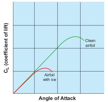
当机翼结冰时,如果迎角很小时,对升力系数的影响很小,但是如果迎角变大,升力系数就差别很大了。

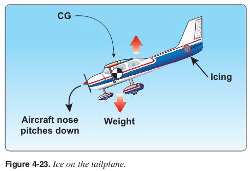
Most aircraft have a nose-down pitching moment from the wings because the CG is ahead of the CP. It is the role of the tailplane to counteract this moment by providing a downward
force. The result of this configuration is that actions which move the wing away from stall, such as deployment of flaps or increasing speed, may increase the negative AOA of the tail. With ice on the tailplane, it may stall after full or partial deployment of flaps.

大多数飞机都存在低头力矩,因为重心在升力中心前,水平安定面产生向下的力平衡飞机。如果水平安定面积冰,飞机将产生无法控制的低头力矩。如果此时增加空速或者放出襟翼,那么升力会变得更大,尾部的负迎角更大,使飞机的低头力矩更大。

ice_tailplane

Duration of Microbursts

evo of a microburst


An individual microburst will seldom last longer than 15 minutes from the time it strikes the ground until dissipation. The horizontal winds continue to increase during the first 5 minutes with the maximum intensity winds lasting approximately 2−4 minutes. Sometimes microbursts are concentrated into a line structure, and under these conditions, activity may continue for as long as an hour. Once microburst activity starts, multiple microbursts in the same general area are not uncommon and should be expected.

常出现在雷暴的大雨区内,单个Microburst持续15分钟。连成片的Microburst可能持续1小时。

Low Level Wind Shear/Microburst Detection Systems

Low Level Wind Shear Alert System (LLWAS),Terminal Doppler Weather Radar (TDWR), WeatherSystem Processor (WSP), and Integrated TerminalWeather System (ITWS) display information on hazardous wind shear and microburst activity in the vicinity of an airport to air traffic controllers who relay this information to pilots.
a. LLWAS provides wind shear alert and gust front information but does not provide microburst alerts. The LLWAS is designed to detect low level wind
shear conditions around the periphery of an airport. It does not detect wind shear beyond that limitation. Controllers will provide this information to pilots by giving the pilot the airport wind followed by the boundary wind.
EXAMPLE:
Wind shear alert, airport wind 230 at 8, south boundary wind 170 at 20.
b. LLWAS “network expansion,” (LLWAS NE) and LLWAS Relocation/Sustainment (LLWAS RS) are systems integrated with TDWR. These systems provide the capability of detecting microburst alerts and wind shear alerts. Controllers will issue the appropriate wind shear alerts or microburst alerts. In some of these systems controllers also have the ability to issue wind information oriented to the threshold or departure end of the runway.
EXAMPLE:
Runway 17 arrival microburst alert, 40 knot loss 3 mile final.

LLWAS只能探测风切变。和TDWR结合后可以探测微爆下击气流。

FAA AC 00-6A Aviation Weather For Pilots and Flight Operations Personnel 民航气象中文版 2014/7/14更新

2014年7月14日更新:
solakzlq@126.com:第34页:在寒潮和向北裹挟着温暖的气流之间,大型的中纬度风暴发展。结果产生了迁移来的中纬度风暴带及多变的天气。第35页:夏季时,温暖的陆地形成低压。而相应地,较冷的海洋形成高压。

FAA AC 00-6A Aviation Weather For Pilots and Flight Operations Personnel 民航气象中文版

网盘下载:

此书所有版权归英文原作者/组织所有。