
某天值班,被机组问到RJNT的两张RNAV图是否都能用?
第一张是RNAV (GNSS) Z Rwy 20
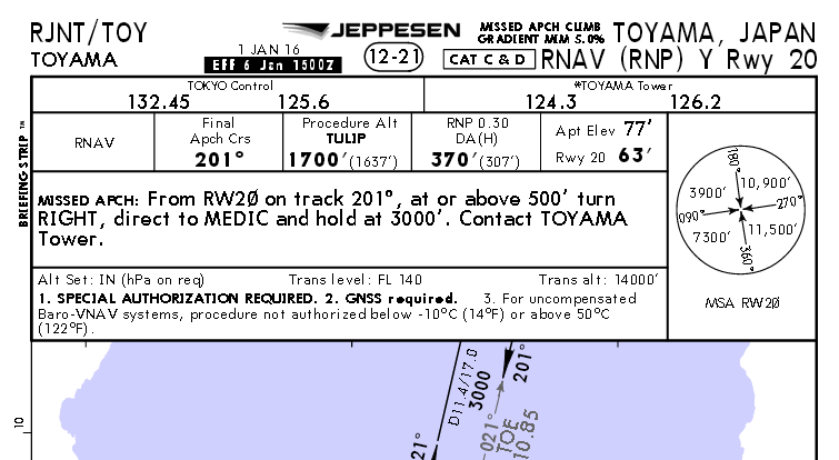
第二张是RNAV(RNP) Y Rwy 20
为什么这两张图长得一样啊~~~精度都是0.3,设备都是GNSS required,只有复飞程序是不一样的。最显著的区别是第二张图多了一句:“SPECIAL AUTHORIZATION REQUIRED”。我觉得第二张图是不能用的,这应该是AR程序的意思。但是我又找不到依据。PBN也是我的弱项(我的弱项很多,呵呵)。
最后咪咪给我答案:
首先在Doc8168中的有这样的定义:
f) RNP APCH: used to support RNAV approach operations up to RNP 0.3, designed with straight segments. May include a requirement for Baro-VNAV capabilities. Obstacle clearan ce criteria are detailed in Part III, Section 1, Chapter 2, and Section 3, Chapters 3, 4 and 7.
g) RNP AR APCH: used to support RNAV approach operations with a final approach segment of RNP 0.3 or lower, designed with straight segments and/or fixed radius segments.
Note.— The criteria to develop RNP AR approach procedures are detailed in the Required Navigation Performance Authorization Required (RNP AR) Procedure Design Manual (Doc 9905) .
定义说RNP APCH是最精确到0.3,可能需要BaroVNAV的直线航段。RNP AR APCH是0.3或更精确的直线航段或固定半径RF转弯航段(AR是被分在另一本DOC里说的,详见Doc9905)。
在Doc8168中第二册第3部份第4章(章节好乱):
4.5.1 The general criteria in Part I, Section 4, Chapter 9, 9.5, “Procedure naming for arrival and approach charts” apply. The instrument approach chart shall be entitled RNAV (GNSS) Rwy XX.
就是图1的命名方式依据。它是一种使用GNSS和气压试高度表的类精密进近。
在Doc9905中:
5.3.2 RNP approach charts depicting procedures that meet the RNP AR APCH navigation specification criteria must include the term RNAV (RNP) in the identification.
这是图2的命名方式依据。它是一个很简单的AR程序,精度只有0.3,没有RF,没要求两部GNSS,也用气压式高度表做垂直。虽然它简单的和图1一样,但是它还是一个AR程序。
正是因为RJNT20号跑道的这个AR程序长得和RNP APCH程序太像了,我们才纠结了那么久(以前也没专门培训过)。如果再看看RJNT02号的那张RNAV(RNP) Rwy 02就不会纠结了。最后有一个弯弯的RF段,没特别批准过肯定没法飞嘛。。。。。。。。。
刚才在看Doc9905的前言,才明白为什么RNP APCH和RNP AR APCH要分在两本DOC里写。等有空了再翻译,最近忙成翔了。